Brush-Everard House Archaeological Report, Block 29 Building 10 Lot 165-166-172Originally entitled: "Brush-Everard House Archaeological Briefing - Block 29 Colonial Lots 165-166-172"
Colonial Williamsburg Foundation Library Research Report Series - 1579
Colonial Williamsburg Foundation Library
Williamsburg, Virginia
1990
BRUSH-EVERARD HOUSE ARCHAEOLOGICAL BRIEFING
BLOCK 29
Building 10
COLONIAL LOTS 165, 166, 172
INTRODUCTION
The Brush-Everard property (Lots 165, 166) is located on the southeast corner of Palace Green and Scotland Street (Figure 1). The Brush-Everard House, which faces Palace Green, is built on Lot 165. This briefing was prepared for the purpose of documenting the development of the Brush-Everard property over the past three centuries. A brief history of the property will be followed by a detailed examination of past archaeological investigations and other disturbances to the property. Using this information, which was compiled from numerous Colonial Williamsburg documents, a statement of future archaeological potential was formulated.
PROPERTY HISTORY
Like most of the properties located within the confines of the colonial town limits of Williamsburg, the Brush-Everard lots have experienced a long and varied history. What follows will be a summary of the property history. For a more complete discussion, see Stephenson (1956).
John Brush purchased Lots 165 and 166 in 1717 and in compliance with the Building Act of 1705, had constructed a frame house (20' x 44' 2") by 1719. Brush, a gunsmith, retained lots 165 and 166 until his death in 1726; at which time the property passed into the hands of his unmarried daughter, Elizabeth Brush, and his son-in-law, Thomas Barbar.
Elizabeth Brush consequently sold her share of the property to Thomas Barbar in 1727. When Barbar died a few months later, in May of 1727, his wife sold the property to Mrs. Elizabeth Russell in 1728. Most likely, Elizabeth Russell married Henry Cary, II, because in 1742, he and his wife, Elizabeth, conveyed Lots 165 and 166 to William Dering. Dering, a dancing teacher and an artist, mortgaged this property in 1744 to Bernard Moore and Peter Hay to secure a debt to William Prentis. Philip Lightfoot later took over this mortgage, and when he died in 1749, his son, William Lightfoot assumed responsibility. Dering apparently moved to Charleston in late 1749, and ownership of this property is uncertain between 1751 and 1779. It may have been purchased in 1751 at an "outcry" by Thomas Everard or John Blair. Archaeological evidence suggests that Thomas Everard may have lived on lots 165 and 166 as early as 1756, when he sold his property on Nicholson Street to Anthony Hay (Frank 1967). By 1779, deed books show Everard as owning lots 165, 166, and 172. Lot 172 was purchased in 1773; but as of yet, no records have been found to date the purchase of Lots 165 and 166.
2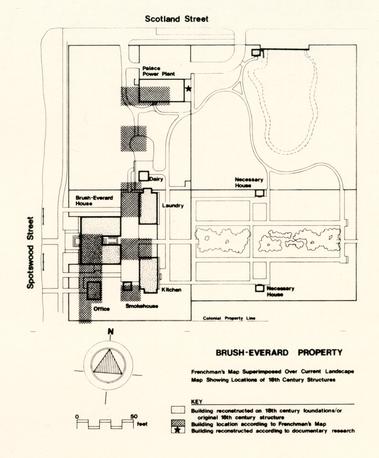 Figure 1. - Map of Property
Frenchman's Map Superimposed Over Current Landscape Map Showing Locations of 19th Century Structures.
After Everard's death in 1781, John Stith was taxed for the three lots formerly belonging to Everard. As seen on the summary of ownership (Table 1), Dr. Isaac Hall owned the property between 1787 and 1788, and then conveyed it to Dr. James Carter. After 1798, the property was taxed to James Carter's estate.
Land tax records between 1820 and 1830 charge the lot and buildings to Milner Peters. From 1830-1847, Dabney Browne owned the property, which he transferred to Daniel Curtis in 1847. Curtis conveyed this property to Sydney Smith in 1849. The property remained in the Smith family until W. A. R. Goodwin purchased it in 1928 for the Williamsburg Restoration. Between 1949 and 1952, the Colonial Williamsburg Foundation restored the Brush House and its outbuildings.
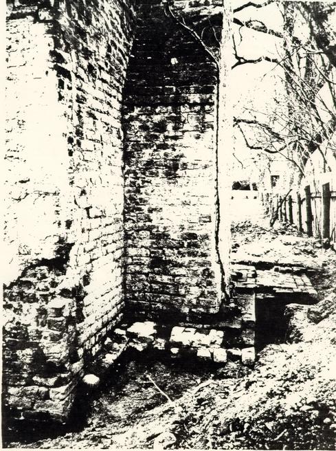
The Frenchman's Map (1782) shows six structures on lots 165 and 166 at the end of the 18th century, of which three have been explored through archaeological investigations and reconstructed or restored. The house, built between 1717 and 1719 by John Brush, was enlarged by the addition of two eastern wings, probably during Thomas Everard's occupation of the property. Around 1780, the southeast wing of the Brush-Everard House was destroyed and a somewhat smaller, modern wing was in place there at the time of the house restoration. Photographs (W89) show the colonial foundation extending approximately 6' east of the modern wing.
The Colonial Williamsburg Foundation purchased the Brush-Everard House in 1928, including in the deed a life-tenancy agreement with its former owners, Misses Estelle and Cora Smith. As the Smith sisters would allow no restoration to take place during their lifetime, the house was not restored until 1947/48.
PRIOR ARCHAEOLOGICAL INVESTIGATIONS
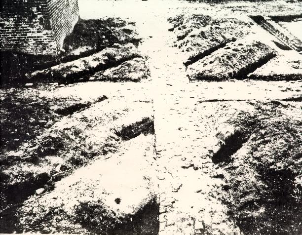
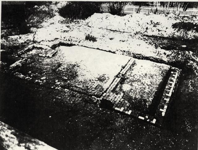
Prior to the restoration of the house, archaeological excavations were undertaken on the property under the direction of James Knight. The areas excavated are defined as Archaeological Areas D, E and F on the 1932 Archaeology and Research Key Map (Figure 2). Photographs from the excavation show the cross-trenching typical of Knight's excavations (Figure 3).
Excavation took place around the house, as well as in the vicinity of the various outbuildings. The results will be discussed in the next section of this briefing. Figure 4 shows all known disturbances to the property.
CHRONOLOGY OF OWNERSHIP
| DATE | OWNER | DATE | OCCUPANT |
|---|---|---|---|
| 1717 | John Brush | 1717-1726 | Brush |
| 1726 | Thomas Barber & Elizabeth Brush | 1726-1727 | Barber |
| 1727 | Thomas Barber | ||
| Susanna Barber | 1727-1728 | Susanna Barber | |
| 1728 | Elizabeth Russell, widow | ||
| 1742 | Henry Cary II & wife, Elizabeth | ||
| 1742/3 | William Dering | 1742-1751 | Dering |
| 1751 | John Blair ? | 1751?-1781 | Everard |
| Thomas Everard? | |||
| 1773 | Thomas Everard | ||
| 1781 | Isaac Hall | ||
| 1781-1785 | Mrs. Susanna Riddle | ||
| 1788 | James Carter | 1788-1790? | Carter |
| 1805 | Mr. Coke (Richard) | ||
| 1812-1820 | Mrs. John Page | ||
| 1820 | Milner Peters | ||
| 1830 | Dabney Browne | 1830-1847 | Browne |
| 1845 | Daniel P. Custis | ||
| 1849 | Sydney Smith | 1849-1928 | Smith & heirs |
| 1881 | Miss Cora & Miss Estelle Smith | ||
| 1928 | W. A. R. Goodwin for Williamsburg Restoration |
 Figure 2. - Archaeological Areas
 Figure 3. - Photograph
 Figure 4. - Map of Known Disturbances
Archaeological Area E
Brush-Everard House
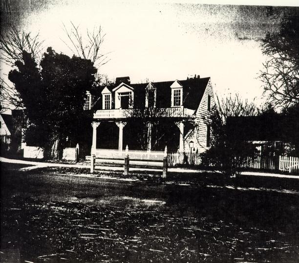
The 1947 excavations around the house uncovered the brick remains of an earlier front entrance. The porch appeared to have possessed a pilastered pediment similar to that of the Archibald Blair house. Although this most likely did not represent the structure's original porch, no other entrance remains were discovered. The long Victorian front porch seen in early 20th-century photographs of the house was added after the Civil War.
Archaeology around the east side of the house revealed the foundations of an earlier wing, thus giving the house an U-shaped plan in the late 18th century.
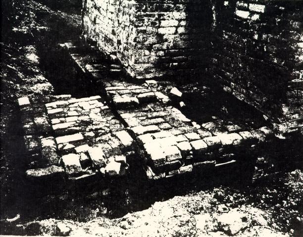
A great deal of brick paving, and several walkways at the rear of the house were revealed approximately 1' below grade. One of the walkways ran east into the boxwood garden; and another ran west from the kitchen door to Palace Green. Several marl walks were also uncovered in the front and on the north side of the house. This brick paving represents the most extensive use of paving in Williamsburg, and has been reconstructed as revealed through archaeological excavation.
In 1933, an underground, sewer line was installed behind the Brush-Everard House, and extended east-west north of the power plant. Another modern feature, on the property was a fence which ran along the east line between the laundry and kitchen and from the south kitchen corner to the southern property line. This fence was removed in 1965.
Open area excavation was most likely used during the 1946/47 excavations around the house, thus lessening the possibilities for any archaeological evidence remaining around the structure.
Boxwood Garden
To the east of the Brush-Everard kitchen and laundry is a large formal boxwood garden. This boxwood is reputed to be the oldest in Williamsburg, between 125 and 150 years old. During the early years of the Restoration, great pains were taken to protect these shrubs. Twenty-two mimosa and spruce were planted in 1934 to shade the boxwood, and earlier that year, screens were put up for the same purpose. In 1946, hornbeam trees were planted as shading; and memos and work orders throughout the 1940s and 1950s mention replacement of boxwood which had died.
9Drainage was apparently also a problem in the Brush-Everard gardens. In 1936, a swale was cut which would drain the area south of the boxwood garden. This water would flow into an open drain that ran "north through the vacant lot of the Brush outbuilding into Scotland Street" (Holland 1936).
The boxwood garden is included in Archaeological Area E. A conversation with former Colonial Williamsburg archaeologist James Knight (Knight 1984) revealed that cross-trenching occurred in the boxwood garden in 1946/47. Trenching at a 45 degree angle to property lines stopped just short of the boxwoods in order to avoid damage to the boxwood roots.
No references about the use of this portion of the property in the eighteenth century were discovered. The area is seen as undeveloped on the Frenchman's Map of 1782 and other 18th century maps of the town.
Outbuildings
Archaeological excavations in 1946/47 also concentrated on locating the structural remains of the Brush-Everard outbuildings as seen on the Frenchman's Map. The colonial period kitchen was still standing to the east of the house; as was an old smokehouse, believed to be original.
Kitchen
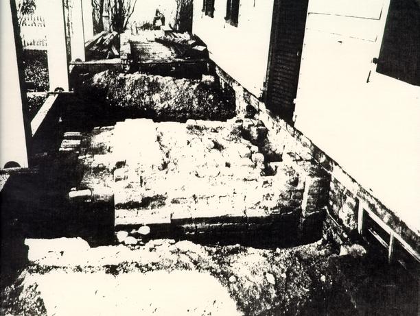
The existing kitchen at the Brush-Everard House is a brick structure measuring 28'7 ½ " X17', with a large brick chimney on the south end. It is the only extant 18th-century, brick kitchen in Williamsburg. Initially constructed as a structure around 1730, it was altered twice during the 18th century. The kitchen was restored between 1952 and 1968. Archaeological excavations were conducted at the kitchen in 1946-47, and again in 1967.
The 1946/47 excavations took place around the exterior foundation walls and located evidence that the kitchen was originally a frame structure. The existing chimney, the south wall and parts of the east and west walls of the kitchen were built on the original chimney foundation. Photos of the 1946/47 excavation show trenching around the outside foundation walls, extending out 1-3 feet from the foundations. The ground outside of these areas does not appear to have been disturbed at that time. These excavations also located step foundations at the southeast corner of the kitchen, and an L shaped brick foundation, which probably served as a support or retaining wall built beside the original chimney. Apparently no excavation occurred inside the kitchen foundations at this time.
10During the 1967 excavations, under the direction of Noel Hume, the entire interior of the kitchen was excavated. This revealed two brick floor sequences and several features cutting into the dirty clay which seemed to represent the earliest floor in the structure. A rectangular pit filled with ashes was located to the west of the hearth. Ashes and iron slag beneath the clay floor, evidence of John Brush's gunsmithing operation on the property, indicated that the kitchen was not in existence during Brush's occupation. For a full description of these excavations, see Frank (1967).
Smokehouse
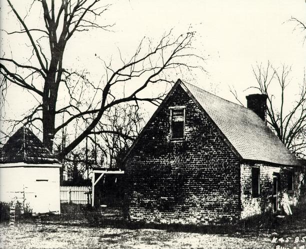
When the Restoration acquired Brush-Everard in 1928, a frame construction smokehouse, set on a shallow brick foundation, was standing to the east of the kitchen. Believed to be a 19th-century structure, this outbuilding was serving as a servant's toilet and for storage in 1942 (Lavery 1942).
Archaeological investigations conducted in 1946 revealed the brick foundations of a small outbuilding (8' 1 ½" x 8') between the Brush-Everard House and kitchen. The wood ashes scattered inside led to the interpretation of this structure as the original location of the smokehouse. It was hypothesized that the existing smokehouse east of the kitchen had originally been located on these foundations; and moved sometime in the 19th century. The frame smokehouse was consequently moved back to its original and present-day location on the west side of the kitchen.
Potting Shed or Office
The Frenchman's Map depicts a small wing on the south side of the Brush-Everard House. Attempts to locate evidence of this wing through excavation (1947) revealed the foundation of an outbuilding, but no addition to the main house. The purpose of this structure, measuring 16' 2' x 12' 3", was not determined, but in the present property interpretation is being treated as a gardener's shed. There was no indication of a chimney foundation on the structure, and the building has been reconstructed in accordance with these findings. It may be important to note here that in Maryland, buildings which housed documents were often constructed without fireplaces (Kandle 1984), perhaps indicated its original use as an office. Running from the doorway on the west side of the building, to Palace Green was a crushed brick walkway.
Laundry
Twenty nine feet north of the present brick kitchen, archaeological excavations uncovered the brick foundations of an outbuilding similar in size to the kitchen (28' 3 ½" NS x 16' 91/2" EW). The north end contained a 8' 4" x 4' 6" chimney. A 9" brick crosswall ran east-west, approximately 7' from the south end of the building. It is postulated that the building was originally 20' 4" NS in length; with weatherboarding on the south end. At a later time, the weatherboard was removed and a 9' 6" addition added to the building.
The original floor surface of well-packed marl was found only in the original portion (20'4" NS) of the building. Near the northwest corner, portions of later brick paving were found. This would seem to indicate that the 9' 6" southern addition appears to have been originally paved with brick, while the original floor of the earlier section was composed of marl.
The building was interpreted as a laundry (perhaps on the basis of its large fireplace) and is not open to the public. A memo discusses the tunnel entrance to the Brush laundry from the main Brush House (Campioli 1950).
Wellhouse
A well, 3'0" in diameter, was located 23' north of the laundry. Although the well head foundation was of modern construction, the brick well lining appeared to be colonial. The only existing remnant of a wellhouse was a 2'2" section of 8 ½" wide brick wall. Today the wellhouse has been reconstructed to the south of the well.
West of the well the remains of a brick box drain were uncovered. This drain carried water from the paved area to the rear of the house and is present today, running north-south past the dairy and well, into the lot housing the Palace Power Plant.
Dairy
Although the archaeological excavations of 1946/47 did not define the location of a dairy on the Brush-Everard property, a small dairy (9 EW x 9'NS) has been reconstructed immediately north of the laundry.
Post Colonial outbuildings (Now Removed)
As seen on the briefing map (Figure 4) there were five outbuildings on the Brush-Everard property which have now been removed. Ten feet north of the house stood a Gothic Revival brick office which had been erected just prior to the Civil War. Measuring 18'NS x 15'EW, the office had small front and back stoops. It was demolished when the house was restored.
In the backyard, just west of the boxwood garden, stood a woodshed and a hen house (photo 83-4113). Both of these have subsequently been removed. The brick foundation of the smokehouse, which was standing east of the kitchen when the property was purchased, was found to date to the 19th century. Subsequently, the smokehouse has now been restored to its original location, within 7' of the kitchen door.
A privy was located on the very eastern edge of lot 172 at the beginning of the 20th century. This has also been removed, and privies reconstructed on the north and south sides of the boxwood garden. There seems to be no documentary evidence for the presence of privies in this or any other location at the Brush-Everard property. It is very likely, however, that archaeological techniques used on the property in 1946/47 would have missed small pit features such as those associated with privies. It is also possible that if such features were discovered, they were not recorded, since the main emphasis on this excavation was for the reconstruction of outbuildings seen on the Frenchman's Map.
Miscellaneous
In a 1965 memo, Don Parker mentioned plans to construct a rough wooden structure on the Brush-Everard property. This building was planned for the storage of cressets. However, no other mention of this project could be found and it is not known whether it was ever constructed. There is no such structure standing on the lot at the present time.
ARCHAEOLOGICAL FEATURES
Archaeological investigations conducted in and around the kitchen area in 1967 revealed some interesting features dating to the 18th century. These are summarized below and discussed fully in Frank (1967).
Ditch (ER1261L)
13Predating and running underneath the kitchen was a square sided ditch (1'5" wide x 1' 6 ½" deep). No material was found in the ditch to reveal its function or its date.
Slots (ER1261 J & N)
Postdating the ditch (1261L) were two shallow slots; possibly representing the locations for the wooden sills of an earlier outbuilding.
Gully (ER1256R)
A natural gully, running in a northeasterly direction, also predated the kitchen construction. This gully was probably filled during the Brush occupation of the property.
Trash Pit (ER1269A)
The first period kitchen builder's trench cut through a trash pit. Artifacts from this feature dated to the period 1725-1730, and possibly represent trash deposited by John Brush.
Fence Lines
A multitude of post holes were discovered running east-west along the southern property line. These holes dated from as early as 1725 to as late as 1850, and represent a jumbled series of property fence lines. Due to the large number of holes, no attempt was made in the 1967 archaeological report to sort the fence sequence and spacing. Audrey Noel Hume, however, in her publication Archaeology and the Colonial Gardener (1974) states that these holes represent the remains of seven fence lines. The present day fence line has been reconstructed 20' 6" too far to the south, when compared with this archaeological evidence.
A large amount of pharmaceuticalia was retrieved from the area of the north kitchen extension. These artifacts dated to the mid-18th century, and predate of pharmacist Dr. Gilmer's occupation of the lot just south of the Brush property. It would seem probable, therefore, that the lot was occupied by an as-of-yet unidentified pharmacist in the mid-18th century.
Archaeological Areas D and F
Palace Power Plant
This structure, measuring 40' EW x 20' NS, is located on Lot 172, at the corner of Spotswood and Scotland Streets. Built in 1933, the building housed boilers for use in heating the Governor's Palace. Although specific reference to an organized archaeological excavation at that time could not be located, later memos (dating to 1946) bear evidence to a small amount of digging which occurred on the lot. When questioned in 1946 about the work (which apparently took place at or near the time of the boiler plant construction), no one at the firm of Perry, Shaw, and Hepburn could remember details of the excavation. The boiler plant was reconstructed, apparently relying on the Frenchman's Map for dimensions of the 18th-century building which had once stood there. A photograph, dated 1933 shows a large (approximately 10' to 15' square x 3' deep) unidentifiable rectangular hole immediately south of the boiler plant (Figure 5).
Under the direction of James Knight, archaeological investigations took place on the lot north of Brush-Everard in 1946/47. Photographs show cross trenching across most of the lot west of the power plant. Artifacts scattered on the dirt piles are evident in the photos. The archaeological report for this area has not been located, although one was apparently written (This report was mentioned in the 1947 Knight archaeological report on Brush Everard property).
In 1967, the building interior was renovated to install public restroom facilities. This probably involved some amount of ground disturbance for utility lines, but no specifications were located. In 1972 or 1973, an underground VEPCO transformer was installed to the northwest of the power plant, and this necessitated ground disturbing activity. The remainder of the lot is vacant, with several fruit trees planted west and south of the building. These trees were planted to conceal the power plant (Campioli 1950a). A dwelling, seen on the 1921 Sanborn Map of Williamsburg, was also located on the Palace Power Plant lot, approximately five feet north of the well. It is not known what effect this structure may have had on archaeological remains in that area.
Activities connected with the Williamsburg Economic Summit of 1983 led to the excavation of an east-west running trench through the field between Brush-Everard House and the Power Plant. The trench stratigraphy revealed a thick layer (2'3") of black loam which extended down from the topsoil horizon. This layer was consistent throughout the 20' length of the trench,
15
 Figure 5. - Photograph
16
and no James Knight cross trenches were evident in the fill. Below this was a layer of redeposited clay, which sealed a grey ash layer containing structural debris. It is possible, given the stratigraphic information, that this entire area was excavated and/or trenched in 1931 and 1946/47 down to the redeposited clay layer, which was mistaken for sterile subsoil. As a consequence, no evidence of structures (which could be contained in the grey ash layer), was discovered to confirm the documentation of the buildings seen on the Frenchman's Map. It is also likely that the 2' of black loam represents a redeposited layer brought in as topsoil for the orchard during the 1930s.
Figure 5. - Photograph
16
and no James Knight cross trenches were evident in the fill. Below this was a layer of redeposited clay, which sealed a grey ash layer containing structural debris. It is possible, given the stratigraphic information, that this entire area was excavated and/or trenched in 1931 and 1946/47 down to the redeposited clay layer, which was mistaken for sterile subsoil. As a consequence, no evidence of structures (which could be contained in the grey ash layer), was discovered to confirm the documentation of the buildings seen on the Frenchman's Map. It is also likely that the 2' of black loam represents a redeposited layer brought in as topsoil for the orchard during the 1930s.
Pond Area
Located to the east of the Palace Power Plant and bordering on Scotland Street is the reconstruction of a colonial pond. In a desire to return the property to its eighteenth century appearance, plans were made to rebuild the pond. Archaeological excavations were conducted in this area by James Knight in 1946 in order to locate the old silt lines of the pond. Correspondence during this planning stage mentions using a bulldozer to excavate the pond, level it off, and haul the surplus soil away. The pond was constructed during 1962/63.
Knight's excavations in 1946 revealed a brick dam running east-west at the northern edge of the pond, with a small outbuilding foundation located at the western edge of the dam. A 6" wide opening in the dam wall suggested the former presence of a water wheel or a mill in the dam. Various letters and memos concerning this dam and the possible interpretations of the site were written in the late 1940s/early 1950s. No agreement could be reached about the possibility of the small outbuilding being a shop or millhouse, and it was finally reconstructed as a privy. The privy was built on the location of the original outbuilding foundations.
Archaeological potential for intact cultural resources in the area of the pond is probably very small due to the pond reconstruction, and the amount of earth-moving it entailed.
SUMMARY
With two previous archaeological excavations conducted on the Brush-Everard Property, impact upon archaeological features located there has been substantial. However, good archaeological potential for portions of the property still exists. This will be discussed and summarized below.
Brush-Everard House and Immediate Yard
Knight cross-trenched this area in 1946/47 and most likely located remains of all outbuildings with brick foundations. Information on refuse patterns, and spatial arrangement of yard use could be gained through excavation in this area. Evidence of Brush's occupation of the house and his gunsmithing operation could also be evident in this area. There may also be good potential in the area directly north of the house, where the Audrey Office used to stand.
Although Ivor Noel Hume concentrated on the kitchen in his 1967 excavations, his work also expanded into the surrounding yard. Most of this work was on the south side of the kitchen and along the property boundary.
Kitchen
Archaeological potential for the kitchen itself is extremely minimal, since Knight's excavations there in 1947 likely destroyed all of the builder's trenches and additional information concerning the early structure and subsequent alterations. The work in 1967 completely excavated the interior of the structure. Potential for further archaeological research as far as interpreting slave quarters there is minimal. Re-examination of the artifact assemblage of a possible root cellar located during the 1967 excavations may be useful, however, since these types of features have been linked to blacks. See page 30 for a summary description of this feature.
Laundry
Cross-trenching located this structure, and it is likely that all of the builder's trenches have been removed. Photographs seem to indicate that the interior fill of the laundry was left intact by archaeologists. Impact through reconstruction is unknown.
Office
Excavation and subsequent reconstruction of this structure has severely impacted the archaeological potential in this immediate area.
Boxwood Garden
James Knight recalls that he cross-trenched the area of the boxwood garden up to the roots of the bushes (Photo L777). No structures were found through his trenching, and there seems to be no archaeological precedent for the two necessary houses which are constructed there today. Archaeological potential in this area is good, and work may reveal evidence of post supported structures in the back of the property, or perhaps remains of prior gardens. The present day boxwood is less than 200 years old and it is not sure what was there prior to its being planted.
Pond Area
Archaeological excavation located the old silt lines of the pond, allowing reconstruction of the pond at its colonial location. In order to build, the pond, earthmoving was done with heavy machinery, thereby effectively destroying any archaeological information which may have remained on the property. The area between the pond and the Palace Power Plant may contain good archaeological potential. It may be possible to determine information about the use of this area for craft activities associated with the dam and small outbuilding. Work in this area would entail the removal of shrubbery which has been planted in this area.
Palace Power Plant and Surrounding Lot
The Frenchman's Map shows three structures located on the lot at the corner of Palace and Scotland Streets. Excavation there in the 1930s (?) and again in 1946/47 failed to yield any evidence of these buildings. Archaeological monitoring of the lot itself over the past several years has shown that the area stratigraphy is characterized by a redeposited fill layer, perhaps associated with the 20th century orchard on the lot. Below this fill is a layer of yellow redeposited subsoil, sealing a deposit containing brick and mortar rubble. The brick and mortar rubble appear to be destruction debris dating to the late 18th/early 19th centuries, perhaps related to the removal of one of the buildings seen on the Frenchman's Map. It is feasible that archaeologist in the 1946/47 work thought that the 19 redeposited clay represented subsoil, and therefore stopped crosstrenching at this level. In that case it is highly likely that archaeological remnants of the structures seen on the Frenchman's Map still exist, virtually untouched, on the property. The Palace Power Plant was constructed directly on top of the area shown to contain the northernmost structure on the Frenchman's Map. It is doubtful that any foundations of this building would be recovered, due to the disturbance created by the construction of this building.
REFERENCES CITED
- 1950a
- Memo to A. Shurcliff dated 1-24-50. Original on file in Brush Everard Landscaping File 1949-1976. Archives Department, Colonial Williamsburg Foundation.
- 1950b
- Memo to H. Beebe dated 5-29-50. Original on file in Brush Everard Landscaping File 1949-1976. Archives Department, Colonial Williamsburg Foundation.
- 1967
- Brush-Everard House Kitchen and Surrounding Area; Block 29, Area E. Colonial Lots 164 and 165. Report on 1967 Archaeological Excavations. Unpublished report on file at Colonial Williamsburg Foundation Library, Williamsburg, Virginia.
- 1782
- Plan de la ville et environs de Williamsburg en Virginie, 1782. Map on file, Colonia1 Williamsburg Foundation Library, Colonial Williamsburg Foundation.
- 1936
- Memo to Anson Gardiner dated 3-10-36. Original on file in Landscaping File (1936) Audrey House, Block 29, Nos. 10, 14, 9, 15. Archives Department, Colonial Williamsburg Foundation.
- 1984
- Personal communication. June 7.
- 1947
- Archaeological Report, Block 29, Area E. Brush House and Outbuildings. Unpublished report on file at Office of Excavation and Conservation, Colonial Williamsburg Foundation.
- 1984
- Personal communication, June 5.
- 1942
- Memo to E. Kendrew dated 5-2-42. Original on file in Brush House File 1941-44. Archives Department, Colonial Williamsburg Foundation.
- 1974
- Archaeology and the Colonial Gardener. Colonial Williamsburg Archaeological Series No. 7. Colonial Williamsburg Foundation, Williamsburg, Va. 21
- 1965
- Memo to W. Geiger dated 9-13-65. Original on file in Brush-Everard Outbuildings File 1949-1950. Archives Department, Colonial Williamsburg Foundation.
- 1968
- The Brush-Everard Kitchen, Original, Block 29. Building 9. Colonial Lot 165. Summary Architectural Report on file at Architectural Research Department, Colonial Williamsburg Foundation, Williamsburg, VA.
- 1956
- Brush-Everard House, Block 29, Colonial Lots 165, 166, 172. Research Report on file at Research Department, Colonial Williamsburg Foundation, Williamsburg, VA.
SUMMARY SHEETS OF STRUCTURES AND FEATURES
FEATURE
Brush-Everard House (original standing structure)
CATALOGUE #
29E
DESCRIPTION
This is a standing structure. Excavations took place around the house, uncovering the remains of an earlier front entrance (probably not original to the house). Also revealed was a wing on the eastern side of the structure, giving the house its present U-shaped plan. On the east side of the house, located between it and the kitchen/laundry complex, was extensive brick paving.
LOCATION
Southeast corner of Palace Green and Scotland Street; Colonial Lot 165.
ASSOCIATED ARTIFACTS REPORTED
ASSOCIATED DEPOSITION OF ARTIFACTS
CURRENT COLLECTION STATUS
INVESTIGATOR
James M. Knight 1946/47
CONDITION
Extensive archaeological work around the house, as well as repairs And additions made during restoration have probably destroyed pertinent features. There is a possibility of original builder's trench being present on the north side of the house.
PAST INTERPRETATION AND SIGNIFICANCE
EXCAVATION TECHNIOUE
Archaeological photos show what appears to be large open areas of excavation abutting the house foundations.
REFERENCES
Photos W105, W104, W89, 49-W-1096
Archaeological Report Block 29, Area E, JMK 1947
Map-JMK-"Archaeological Survey of Foundations on Brush Lot" 1947.
 Photograph 48-W-375
West Elevation before Restoration
 Photograph W104
 Photograph W89
 Relationship of features associated with Brush-Everard Kitchen to elements of the First Theatre site.
FEATURE
Kitchen (Original standing structure)
CATALOGUE #
in 29E
DESCRIPTION
Brick structure measuring 28' 7 ½" x 17' with large brick chimney at south end.
LOCATION
East of the southeast wing of the Brush-Everard House.
ASSOCIATED ARTIFACTS
REPORTED DEPOSITION
CURRENT COLLECTION STATUS
INVESTIGATOR
James Knight 1946/47
Ivor Noel Hume 1967
CONDITION
The kitchen has been completely excavated, with virtually no archaeological potential remaining.
PAST INTEPRETATION AND SIGNIFICANCE
This building was initially constructed as a frame structure, and was twice remodeled in the 18th century.
EXCAVATION TECHNIOUE
Knight-trenching around the exterior foundation walls and chimney base
Noel Hume-complete removal of building's interior fill.
REFERENCES
- 1.Frank (l967)
- 2.Archaeological Report, 1947 (JMK)
- 3.Map Archaeological Survey of the Foundations on the Brush Lot, JMK, 1947.
 Photograph of Kitchen
 Photograph W85
 Photograph W88
FEATURE
Reconstructed Pond
CATALOGUE #
29F
DESCRIPTION
This pond has been reconstructed after archaeological excavation revealed its old silt line.
LOCATION
Pond fronts onto the south side of Scotland Street, east of the Palace Power Plant (Building 13B).
ASSOCIATED ARTIFACTS
none
REPORTED DEPOSITION
none
CURRENT COLLECTION STATUS
INVESTIGATOR
James M. Knight 1946
CONDITION
Bulldozers were used to excavate and level pond for reconstruction. Archaeological potential in this area is minimal, if not nonexistent.
INTERPRETATION AND SIGNFICANCE
EXCAVATION TECHNIOUE
Knight trenched the pond in order to find silt lines; bulldozers later brought in for pond reconstruction.
COMMENTS
See also feature sheets on brick dam and outbuilding following.
REFERENCES
- 1.Memo to Shurcliff from Campioli 1-24-50 (landscaping File, Brush-Everard 1949-76).
- 2.Letter to Campioli from Shurcliff, 12-20-49.
- 3.Letter to Shurcliff from Hopkins 9-28-49. All the above information from Landscaping File, Archives.
- 4.W110-3-7-47A, 47W-767, W111-3-7-47A
- 5.Sketch map showing trenching through pond area (Architectural Research Department, Archaeology File on Brush-Everard).
FEATURE
Brick Dam
CATALOGUE #
29F
DESCRIPTION
Brick dam running east-west at northern end of pond, small outbuilding foundation at western edge, 6" wide opening in dam wall, suggestive of water wheel location.
LOCATION
Northern edge of pond skirting south side of Scotland Street
ASSOCIATED ARTIFACTS
none
REPORTED DEPOSITION
CURRENT COLLECTION STATUS
INVEGTIGATOR
James M. Knight 1946
CONDITION
Dam has been reconstructed, with destruction of Archaeological potential through excavation.
EXCAVATION TECHNIOUE
Complete exposure of dam on all sides by open area excavation.
ADDITIONAL COMMENTS
There was some disagreement among CWF officials about whether the 6" wide opening in the dam was actually for a waterwheel and if the small building beside it was a mill.
REFERENCES
- 1.Memo to Beebe from Campioli, 9-29-50
- 2.Letter to Shurcliff from Hopkins, 9-28-49
- 3.Photos-Wl07-2-18-47A,, W108-2-18-47A
- 4.Field Sketch of dam and small outbuilding foundation (Brush Everard Archaeology File, Architectural Research Department.)
FEATURE
Outbuilding west of pond.
CATALOGUE #
29F
DESCRIPTION
Brick foundation remains of small frame outbuilding.
LOCATION
At the south edge of Scotland Street, located east of the Palace Power Plant and west of pond.
ASSOCIATED ARTIFACTS
none
REPORTED DEPOSITION
CURRENT COLLECTION STATUS
unknown
INVESTIGATOR
James M. Knight 1946
CONDITION
Trenching around brick foundations and new outbuilding reconstructed Directly on location of old foundations.
PAST INTERPRETATION AND SIGNFICANCE
Much discussion on whether this structure represented a shop or mill associated with the dam (See Archives Landscaping Files).
EXCAVATION TECHNIOUE
Open area excavation around and inside foundations; some stratigraphic layers may be present on the outside of the foundation
ADDITIONAL COMMENTS
This structure was finally reconstructed as a privy, although archaeological excavations did not indicate that this was a privy.
REFERENCES
- 1.Memo to Shurcliff from Campioli 1-24-50 (Landscaping File, Brush-Everard 1949-1976, located at Archives Department)
- 2.Photos-Wl07-2-18-47A
- 3.Field Sketch of dam and small outbuilding, ¼" = 1.0' Brush-Everard Archaeology File, Architectural Research Department.
FEATURE
Smokehouse
CATALOGUE #
within 29E
DESCRIPTION
Brick foundation of small (8' x 8' 1 ½") frame structure believed to have served as a smokehouse.
LOCATION
Between Brush-Everard kitchen and Brush-Everard House. 6'5" west of kitchen, 14' 2 ½" south of southern corner of Brush-Everard House.
ASSOCIATED ARTIFACTS
REPORTED DEPOSITION
CURRENT COLLECTION STATUS
INVESTIGATOR
James M. Knight 1946
CONDITION
Foundation wall trenched around outside, inside of structure has also been excavated--from photo W80, there appears to be a feature (modern?) cutting through remaining fill inside structure. Minimal archaeological potential.
PAST INTERPRETATION
1947--Knight "inside this foundation ..was ... small bed of wood ashes ... typical of colonial smokehouse foundations"
1947--Knight-location of ash bed, plus location of brick paving along north side of foundation may indicate door in north-side.
EXCAVATION TECHNIOUE
Cross-trenching located foundation, then foundations trenched around outside; at least some fill removed from inside structure.
ADDITIONAL COMMENTS
It is believed that this foundation is original 18th century location of the smokehouse. It was hypothesized that the existing smokehouse east of the kitchen had originally been located on these foundations and consequently was moved back during restoration.
REFERENCES
- 1.1947 Archaeological Report, James Knight, Block 29, Area E.
- 2.1947 Map "Archaeological Survey of Foundations on Brush Lot, 1947" JM
- 3.Photo W80
 Photograph W80
 Photograph W87
FEATURE
Potting Shed or Office
CATALOGUE #
in 29E
DESCRIPTION
8 ½" thick brick foundation measuring 16' 2" x 12' 3"- contained no chimney foundations.
LOCATION
14'5 ¾" south of the Brush-Everard House, 7' east of front line of Brush House and 2' north of southern property line.
ASSOCIATED ARTIFACTS
REPORTED DEPOSITION
CURRENT COLLECTION STATUS
INVESTIGATOR
1947 James M. Knight
CONDITION
Minimal archaeological potential due to excavation and current reconstruction of the building.
PAST INTERPRETATION
1947 Knight- "no indication of a chimney foundation" located, so building has been reconstructed and currently interpreted as a gardener's shed.
1947 Knight- "probably used as small shop or office by the occupants of the large house".
EXCAVATION TECHNIQUE
Located through cross-trenching inside and outside foundation walls with at least some of fill inside structure removed.
ADDITIONAL COMMENTS
REFERENCES
- 1.1947 Knight Archaeological Report Block 29, Area E.
- 2.1947 Map "Archaeological Survey of Foundations on Brush Lot" James Knight.
- 3.Photos--W78, W79.
 Photograph W79
FEATURE
Walkway
CATALOGUE #
within 29E
DESCRIPTION
4' area of crushed brick walkway running e-w from 16'2" x 12'3"structure (potting shed or office).
LOCATION
Running east-west, leading from Palace Green to the potting shed or office to the south of Brush-Everard House.
ASSOCIATED ARTIFACTS
REPORTED-DEPOSTION
CURRENT COLLECTION STATUS
INVESTIGATORS
James M. Knight 1946/47
CONDITION
not given, probably destroyed by reconstruction of potting shed/office.
PAST INTERPRETATION
1947 Knight--" evidently was a walkway from the outbuilding entrance to the Street or Palace Green".
EXCAVATION TECHNIOUE
Revealed through cross-trenching, uncovered most likely by shovel testing.
ADDITIONAL COMMENTS
REFERENCES
- 1.1947 Knight Archaeological Report, Block 29, Area E.
- 2.1948 Map "Archaeological Survey of Foundations on Brush-Everard Lot", J. Knight
 Photograph W100
FEATURE
Laundry
CATALOGUE #
within 29E
DESCRIPTION
Brick foundation of an outbuilding 28' 3 ½" NS x 16' 9 ½" EW. The north end contained a 8'4" x 4'6" chimney and a 9" brick crosswall ran e-w, approximately 7' from south end.
LOCATION
29' north of present brick kitchen.
ASSOCIATED ARTIFACTS
REPORTED DEPOSITION
CURRENT COLLECTION STATUS
INVESTIGATOR
James M. Knight, 1946/47
CONDITION
Builder's trenches on inside and outside of foundation appear to have been destroyed by excavation. Report does not indicate whether marl floor in north portion, or the brick floor in the southern addition was removed and excavation conducted underneath. This building has been restored and construction most likely destroyed any areas of archaeological significance remaining.
PAST INTERPRETATION
This building was interpreted as a laundry due to its large chimney.
ADDITIONAL COMMENTS
REFERENCES
- 1.1947 J. Knight Archaeological Report, Block 29, Area E.
- 2.1947 Archaeological Map on Brush Property.
 Photograph W95
FEATURE
Rectangular Pit (Possible Root Cellar?)
CATALOGUE #
E.R. 1256 E-J
DESCRIPTION
Rectangular pit found beneath the lower brick floor of the Brush-Everard Kitchen, west of the reconstructed fireplace. This pit contained five layers, two of which were ash filled. Terminus post quem for the bottom layers provided by ceramics dating to c. 1790-1800.
LOCATION
West of the reconstructed fireplace in the Brush-Everard Kitchen.
ASSOCIATED ARTIFACTS REPORTED
ASSOCIATED DEPOSITION OF ARTIFACTS
CURRENT COLLECTION STATUS
INVESTIGATOR
Noel Hume 1967
CONDITION
The feature was entirely removed through archaeological investigations, and is only recoverable through excavations notes, maps, and artifact analysis. The Brush-Everard kitchen has been restored, and a mud floor constructed in this structure.
INTERPRETATION AND SIGNIFICANCE
Although this feature was not discussed as a root cellar in the 1967 report, more recent archeological excavations have pointed to the occurrence of such features in structures occupied by blacks. Since it is believed that slaves did live in the Brush-Everard Kitchen, this feature may hold significance to the interpretation of black life in Williamsburg.
EXCAVATION TECHNIOUE
Hand excavated (most likely) by stratigraphic layers.
REFERENCES
- 1.Frank (1967)